.png)

SHEPHERD™
Predator Detection & Deterrence Solution
DETECT THE RISK. DETER THE LOSS.
SHEPHERD™ combines strategically deployed detection and deterrence capabilities with 24/7 professional remote monitoring and immediate notification following review and verification. It delivers actionable information and landscape-level awareness to help protect livestock, pets, apiaries, crops, property, and people where human activity and wildlife share the landscape.
We don't want to simply witness the damage or loss. We want to help you prevent it.
Detect Earlier. Respond Faster. Reduce Risk.
Traditional wildlife conflict response often begins after livestock, pets, apiaries, crops, or property have already been damaged or lost. SHEPHERD changes that sequence by enabling earlier detection and response to wildlife activity before it results in damage or loss.
Detect
Strategically deployed detection capabilities monitor priority areas for early detection of wildlife species of interest to the client. WCS staff review detections to identify the species and characterize observed behavior before determining the appropriate response.
Deter
When appropriate, WCS staff remotely activate nonlethal deterrence capabilities to immediately discourage or interrupt wildlife behavior that may lead to damage or loss.
Notify
WCS staff notify designated contacts of detected wildlife, including the species identified, observed behavior, and other pertinent information. Clients establish notification preferences by species, day, time, contact method, and designated contact.
Map
With client authorization, verified detections can be added to Wildlife Detection & Mapping to show where and when wildlife activity occurs across the landscape. Participation in shared mapping is optional and governed by the client's data-sharing preferences.
Explore Wildlife Detection & Mapping ↓SHEPHERD isn't designed simply to document the presence of wildlife. Anyone can do that.
The objective is to create an opportunity to act before that presence can lead to conflict.
Protection Designed Around Your Property
No two properties present the same wildlife risk. A cabin in the Tahoe Basin requires a different deployment than a small rural property with goats concentrated near a barn or a cattle operation spanning thousands of acres of private ranchland or public grazing allotments. Terrain, vegetation, livestock locations, apiaries, crops, wildlife travel areas, connectivity, and access all influence system design. SHEPHERD therefore begins with the site and operating environment — not with a predetermined equipment package. WCS evaluates the property, identifies priority monitoring and protection areas, and designs the deployment around the species of interest, resources, risks, and operational priorities that matter to the client.
Designed to Grow With the Risk
Start with priority areas and wildlife species of interest, then expand coverage, mapping participation, or other SHEPHERD capabilities as needs change.
Property Assessment
Identify vulnerable animals, structures, apiaries, crops, travel corridors, access points, likely wildlife approaches, and other areas of concern.
Strategic Deployment
Position system capabilities where they can provide meaningful monitoring and deterrence rather than simply maximizing equipment count.
24/7 Professional Monitoring
WCS personnel continuously monitor the deployed system so clients do not have to watch camera feeds, sort through detections, or determine for themselves whether an event warrants attention.
Actionable Intelligence
Relevant detections are converted into useful information the client can act upon — including what was detected, where it occurred, what behavior was observed, and when it happened.
Detection Layer
Strategically positioned capabilities used to detect wildlife activity and provide WCS staff with the information needed to assess detections and determine the appropriate response.
Protection Layer
Strategically positioned nonlethal deterrence capabilities that WCS staff can remotely activate when appropriate to help reduce the risk of damage or loss.
Consultation & Onboarding
Every Property Is Different.
Every property is different. So is every wildlife conflict. WCS begins by evaluating the property, selected species, existing infrastructure, operating environment, connectivity, and protection priorities before recommending an appropriate SHEPHERD deployment.
More Than a Camera Network
SHEPHERD is not simply a collection of cameras or sensors.
It is a professionally managed detection and deterrence solution combining strategically deployed field technology, wildlife expertise, deterrence capability, persistent monitoring, communications, and spatial awareness.
The client receives the capability without having to design, integrate, monitor, or manage the underlying system.
Wildlife Detection & Mapping
See More Than an Individual Detection
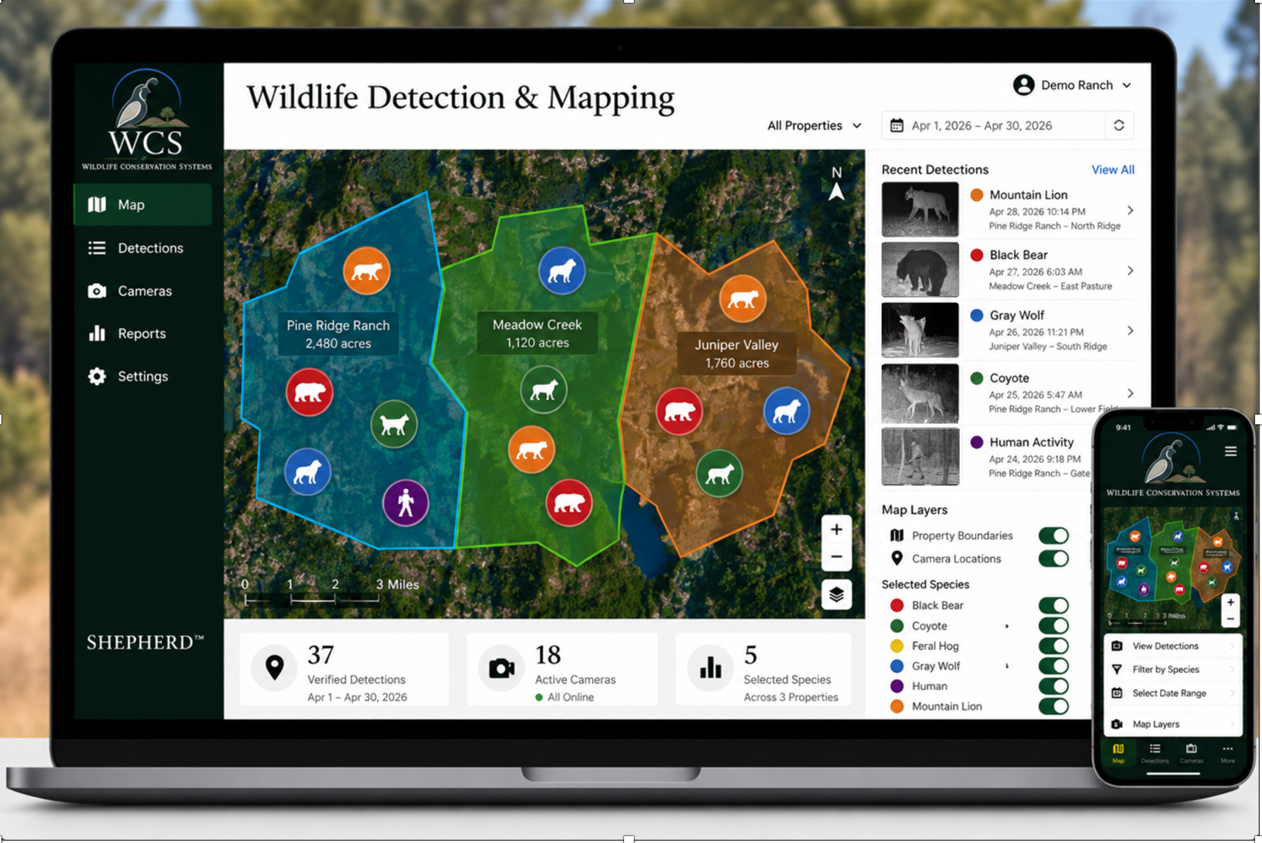
Wildlife Detection & Mapping provides real-time visualization of verified detections, allowing participating properties to view relevant wildlife activity spatially rather than as isolated events.
See More Than an Individual Property
Wildlife does not recognize property lines. A verified detection on one property may therefore matter to another nearby. As SHEPHERD deployments expand across a landscape, participating clients gain broader awareness of where selected species are appearing over time.
Individual Protection. Collective Awareness.
Participating properties can opt in to contributing eligible verified detections to the mapping database, expanding collective awareness as SHEPHERD coverage grows.
Confidentiality: WCS maintains participating-property information in accordance with established confidentiality, security, and data-sharing protocols.
Built to Address Wildlife Risk Before It Becomes Damage or Loss
Livestock
Support protection of cattle, sheep, goats, poultry, horses, and other domestic livestock near corrals, pastures, barns, loafing areas, watering locations, and other vulnerable areas.
Pets
Provide additional situational awareness for properties where dogs, cats, or other companion animals may encounter predators or other wildlife.
Apiaries
Help identify and respond to wildlife activity that may threaten hives, equipment, honey production, or other apiary resources.
Crops & Agricultural Operations
Provide monitoring and wildlife awareness around crops, orchards, fields, livestock operations, and other agricultural resources that may be exposed to wildlife-related damage.
Residential, Cabin & Rural Properties
Monitor wildlife presence around homes, cabins, outbuildings, driveways, animal enclosures, and property boundaries where wildlife activity may create a risk of damage or loss.
Public & Conservation Lands
Potential applications include research, grazing allotments, wildlife monitoring, conflict reduction, and other circumstances where remote detection and spatial wildlife awareness provide management value, subject to applicable land-management rules and authorizations.
Selected Species
SHEPHERD's core mission is predator detection and deterrence. Its managed monitoring architecture can also be configured for other selected wildlife species and, through Property Intelligence, certain unauthorized human activity.
- Gray Wolf
- Mountain Lion
- Black Bear
- Coyote
- Feral Hog
- Other Wildlife Species
Beyond its core predator applications, SHEPHERD can be configured to monitor other selected wildlife where detection provides management or property-protection value.
System configuration, monitoring requirements, deterrence options, and applicable legal requirements vary by species and location.
24/7 Professional Monitoring
Consumer wildlife cameras can tell you that something passed in front of a camera. SHEPHERD is designed to do more. WCS personnel monitor relevant detections 24 hours a day, 7 days a week. When an event meets the client's established criteria, WCS staff identify the species, characterize observed behavior, evaluate the situation, and provide notification according to the client's preferences. This human review helps distinguish meaningful events from routine wildlife activity and provides the client with context rather than simply forwarding an unfiltered camera alert.
Detection is the beginning of the process — not the end.
Property Intelligence
Protection Doesn't End With Wildlife.
The same managed detection infrastructure that supports SHEPHERD's wildlife mission can also provide participating clients with additional situational awareness of unauthorized human activity. Where selected by the client, Property Intelligence can help identify potential trespassing, poaching, theft, or other unauthorized activity within monitored areas and provide notification according to the client's established preferences. This capability complements SHEPHERD's wildlife functions without changing its primary purpose as a predator detection and deterrence solution.
Optional Capability
Where selected by the client, Property Intelligence can help identify potential:
- Trespassing
- Poaching
- Theft
- Other unauthorized activity
Property Intelligence supplements SHEPHERD's wildlife functions and is not intended to replace a conventional security system.
Frequently Asked Questions
Get Started
Request a SHEPHERD Consultation
Request a no-obligation consultation to determine whether SHEPHERD is appropriate for your property.